Border to Border Expedition
A
Cross-Country
Outing with
Expedition
Campers
20160711-26
Final Update: 20160726 from San Diego, CABack to Bill Caid's Home Page.
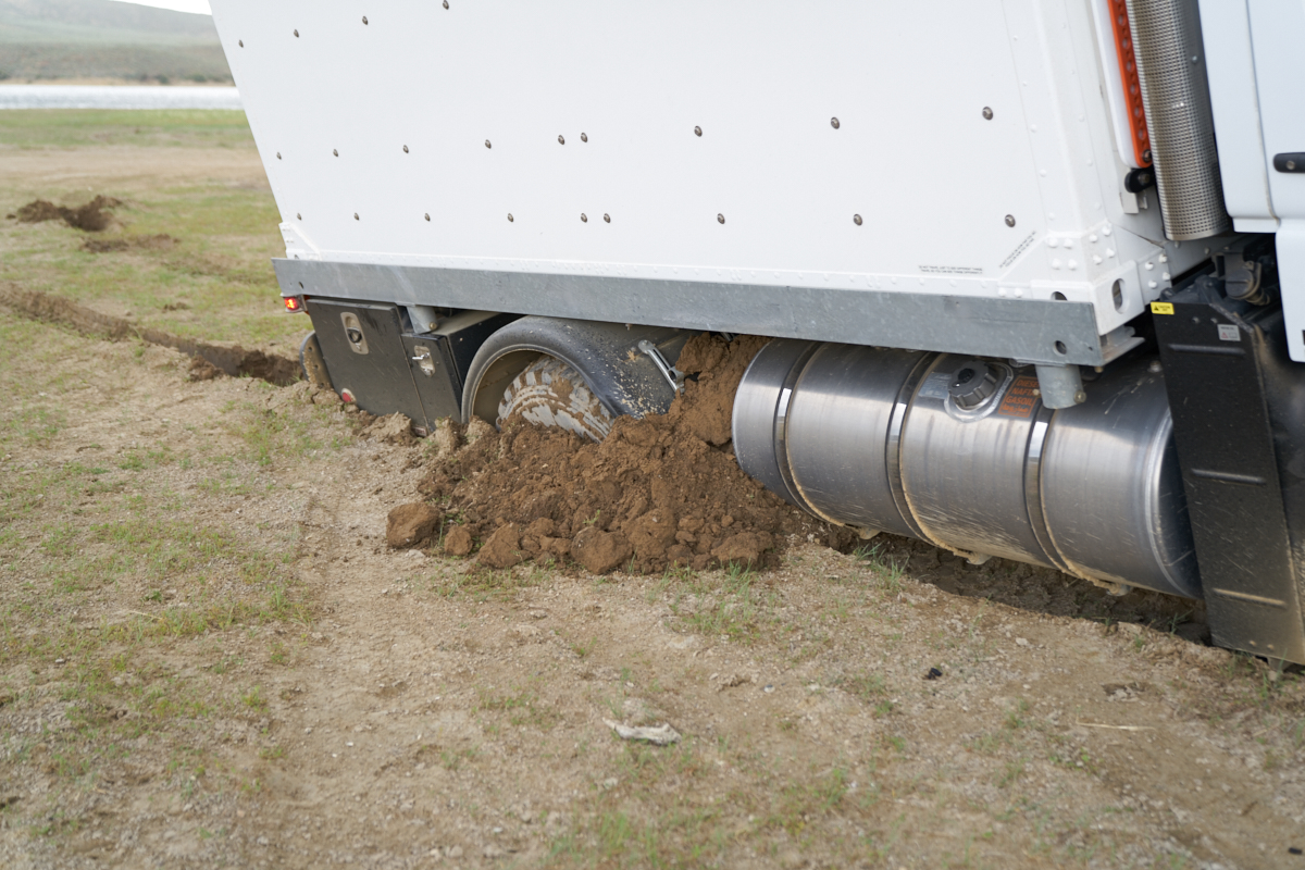
Can you say "stuck"? Soft ground befouls a U500 at Flaming Gorge Reservoir, WY.
Sony A7RM2: 1/125 sec, ISO 125, 46mm at f/2.8
All photos copyright, Bill Caid 2016. All rights reserved.
The Trip
We met our buddies in Douglas, then headed east along the border on the Geronimo Trail.
Tracking Our Location Via The SPOT
Some years ago, after a scary mechanical failure in the canyons and mesas of southern Utah, we decided that we need a better way to advertise our position and call for assistance if needed. Kathleen found out about the SPOT which is a GPS locator that transmits your coordinates via satellite so that others can see your location. The location is plotted on Google maps and a "bread crumb" feature is available for an additional fee. We have the enhanced service, so you can see our historical path back 50 updates or so. See our current location plotted on Google Maps in Real-Time via SPOT satellite geo-locator device. This page is "book-markable" and is updated approximately every 15 minutes, but may miss updates due to inability of our transmitter to reach the satellite. The communication is "open loop" so the device never knows if it's messages are actually going anywhere, it just keeps trying until the next update is available. If we are in a congested urban area with high buildings (like Manhattan) or in deep canyons, the position may not update. We try to send an "OK" message once a day just to let everyone know that we are, in fact, OK. Given that London as well as other remote areas has many obstacles (like mountains), it is not clear how well this capability will perform.Connecting and Contacting Us While on the Trip
Because of internet connectivity issues on a previous trip, we purchased a MiFi cell phone modem that allows us to connect nearly anywhere there is at least 3G service via cell phone (which is most of the cell phone service area available today). But, as we all know, cell phones are useful many places, but not everywhere has coverage, particularly in the remote areas of the country and outlying territories. Our phones and the modem are enabled daily so you may contact us, although it may take a few days for us to respond. But, we will respond. My email, spelled out, is "bcaid at yahoo dot com".Trip Details
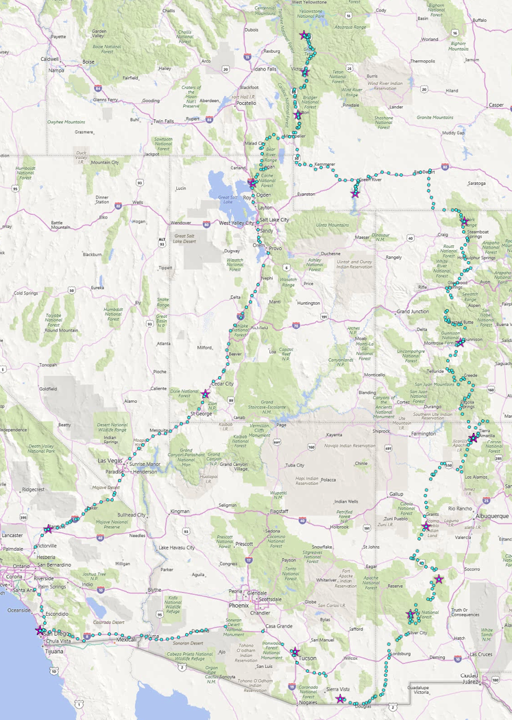
Route traveled on this trip.
The
link table
below contains
links to the
photos and
dialog
for each of
the days of
the
expedition.
This table
will be
updated as the
trip
progresses.
| Part | Dates | Adventure Locations |
|---|---|---|
|
1
|
20160711
|
Douglas, AZ to Gila River, NM
|
| 2 |
20160712-14 |
Gila River, NM
to Grants, NM |
| 3 |
20160715-16 |
Grants, NM to
Chama, NM |
| 4 |
20160717-18 |
Chama, NM to
Steamboat Springs, CO |
| 5 |
20160719-21 |
Steamboat
Springs, CO to Afton, WY |
| 6 |
20160721-22 |
Afton, WY to
Yellowstone, WY |
| 7 |
20160723-26 |
Jackson, WY to
San Diego, CA |
Conclusions and Advice to Travelers
The weather in the southwest during the summer can be
challenging. Hot temperatures and burning sun create a
situation where travelers must be mindful of dehydration and
sunburn. If you travel in the area, you will need to
allocate plenty of water per person (4-8 liters per person per
day, depending on the temperature) and plenty of sunblock.
You may want to consider bringing a big bottle of Thermotabs
which are electrolytes in pill form. These will help stave
off electrolyte related heat distress. Weather on the
route varies from burning heat in the valley floors during the
day to shivering cold during the nights at altitude, so bring an
appropriate range of clothing.Back to Bill Caid's Home Page.
Copyright Bill Caid 2016