
This
section of the trip was simple, but hard. The simple part
was getting from point A to point B. The harder part was
coordinating with the other members of the expedition, friends and
family. We left Tucson and went to visit our long time
friends Rick and Kim in Chandler. After a delightful night,
we hit the road again and headed north toward Flagstaff to
rendezvous with the Overland Expo crowd. But, the U500 group
made a decision overnight to change the schedule. So, we had
to coordinate the changes via cell and text messages. We
were able to accommodate to the real-time changes and meet the
group in Flagstaff. After food for the humans and food for
the trucks, we headed north toward Marble Canyon.
The photos below are what we saw.
Before
we left the parent's place in Tucson, I got this photo of one of
the barrel cactus in the yard with blooms.

We
traveled to Chandler and met our long-time friends Rick and Kim
and stayed overnight at their awesome home. Next morning, we
headed north to Flagstaff and finally met the balance of our group
at the Walmart in Flagstaff. We had to do a parking lot
line-up for benefit of the local shoppers; there were plenty of
craned necks checking out the trucks.

This
is Chris and Anne's U500 camper with pop-top roof.

Mark
and Gail's Global Expedition Vehicle (GVX) U500.

Vince's
home-brew U500 camper with ex-mil command shelter as the camper
box.

After
food for the trucks and humans, we headed north on US89 toward
Page, AZ. Our plan was to go to a camp site that was on the
lip of the Colorado River in Marble Canyon and spend the
night. Above is a photo of the old bridge that spans the
Little Colorado River on the Navajo Reservation.

There
was just a little water in the Little Colorado river bed but a few
days prior it had been running hard due to spring rains in the
high country.

Further
north we came to the gray mud hills that are formed by the
Moenkopi formation.

Interesting
erosion patterns were formed in the mud hills.

As
we gained elevation, the type of formations changed as well.

I
was shocked to see this sign on a bridge that crosses the Colorado
River in Marble Canyon. Not because of the intent of the
sign, but rather the uselessness of it. The bridge is over
400 feet from the surface of the river, so jumping is out of the
question for a normal person. And, if the intention was to
commit suicide, then the person won't care about the sign anyway.

The
new bridge on US89 is an engineering marvel.

The
mighty Colorado River, tamed in the 1960s by the Glen Canyon
Dam, provides an awesome sight at the bottom of the 400 foot
gorge.

The
sign gives the stats on the original bridge.

The
old bridge is on the left, the new on the right. The old
bridge is open to foot traffic and photos.

It
was getting late in the day, so after a bio-break at the overlook
point, we headed out toward the Marble Canyon campsite.

A
better view of the old bridge. This was constructed out of
hand riveted steel.

To
get to our Marble Canyon overlook, we had about 30 miles of
dirt. The road had been recently graded, but we could only
go about 25 mph on most of the parts. Above we do a
road-side stop to insure that the group is together.
We
finally arrived at the overlook camp site and it was better than
expected. While a bit breezy, the view was off-the-chart,
even in the waning daylight.

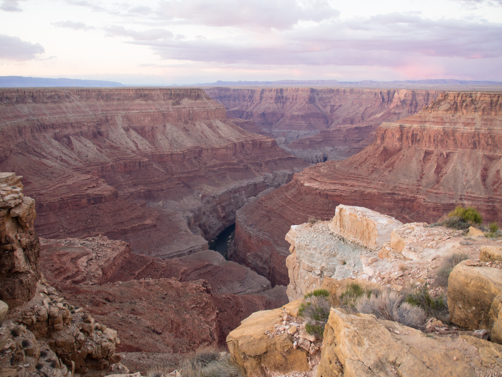
The
Colorado River at the bottom of Marble Canyon was clearly visible
in the deepening shadows.

Our
camp was just feet from the lip of the chasm on the end of a point
that gave us a 180 degree view of the main river channel and its
side canyons. Above is a photo of Thor, our 1017A-based
camper before the top was raised.

Mark
and Gail's GVX U500.

Rob
gets his evening beer ration.
| Previous Adventure | ||
| Trip Home Page |
Photos and Text Copyright Bill Caid 2013,
all rights reserved.
For your enjoyment only, not for commercial use.